About
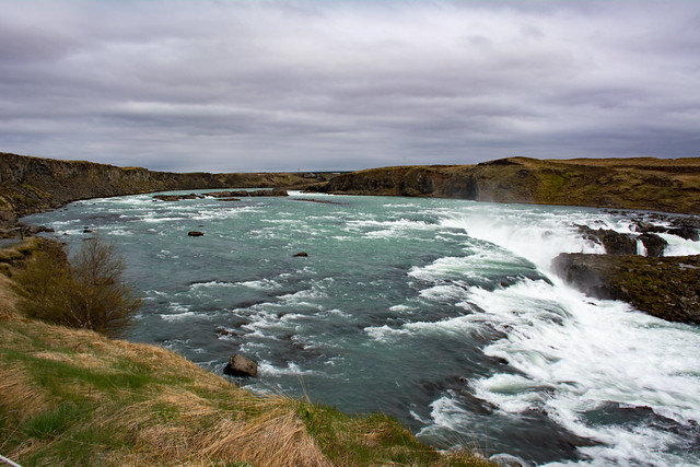
The South Coast of Iceland’s charm lies in its many large and impressive waterfalls and glaciers and unique geology. The eastern part of South Iceland is dominated by the glacier Vatnajökull and the glacials rivers linked to it. Big rivers flow from the glacier in all directions and have created large flood planes along the southern coast. The glacier itself as well as some of the surrounding areas form Vatnajökull National Park.
Hostels
Skogar Hostel
An absolutely incredible location right next to Skógafoss waterfall, just 3min walk from the waterfall. A great midway location between Reykjavik and the glaciers further to the east. Located just of the main ring road. Staff are very friendly and the facilities very clean. Wifi only works in the foyer area which is a bit of downer these days. But overall a very good option. Book Skogar Hostel here!
Vik Hostel
Vik is a beautiful town and while it is very small, it does have decent facilities which makes it an ideal spot to spend a few nights. There is a lot to see in and around Vik as well and staying in the town itself makes a lot of sense. There are also some nice hikes into the hills around Vik and the staff at the hostel have good information for this. Book Vik Hostel here!
Sights and Highlights
Urriðafoss
Urriðafoss is a waterfall in Þjórsá River. Þjórsá is Iceland’s longest river at 230 km, and Urriðafoss is one of the most voluminous waterfalls in the country however. However with a total drop of only 3m it is not as impressive as many of the other high volume waterfalls. Urriðafoss drops down by the edge of the Þjórsárhraun lava field, the result of the greatest lava flow on earth since the Ice Age. Located right off Route 1.
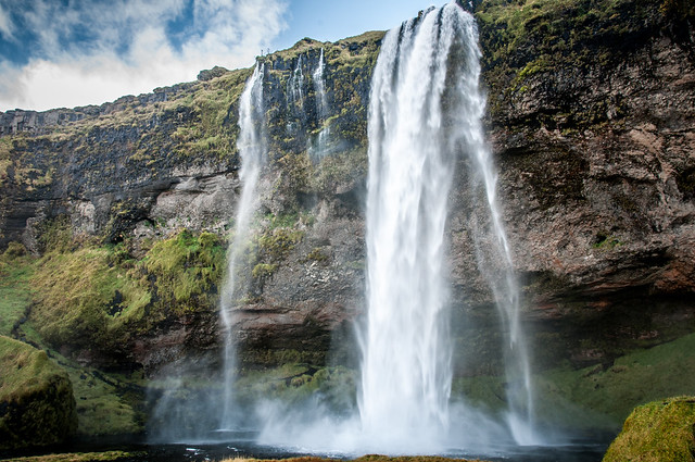
Seljalandsfoss
Seljalandsfoss is one of the best known waterfalls in Iceland most popular tourist stops. It is located right by Route 1 and the road that leads to Þórsmörk, Road 249. The waterfall drops 60 meters and is part of the Seljalands River that has its origin in the volcano glacier Eyjafjallajökull. It is possible to walk behind the waterfall into a small cave.
Gljúfrafoss
Gljúfrafoss (“one who lives in the canyon”) is a hidden waterfall a short walk north of the larger falls of Seljalandsfoss. The falls are partially obscured by the cliff rock, but hikers can follow a trail to enter the narrow canyon where the water plummets to a small pool. There is a small trail and wooden staircase to the right of the cave entrance that enables sightseers to climb roughly halfway up and view the falls from a higher perspective. A lot of care needs to be taken when climbing to this platform, particularly in winter when it is very slippery.
Eyjafjallajökull Erupts Museum
The 2010 eruptions of Eyjafjallajökull which, although relatively small for volcanic eruptions, caused enormous disruption to air travel across western and northern Europe. During April about 10 million travellers had flights cancelled as about 20 countries closed their airspace. This event ultimately became a boon for the tourism industry in Iceland as images of South Iceland were beamed around the world. The resulting uplift in tourism has not slowed since and has helped contribute to the recovery of Iceland’s economy after the Icelandic banking sector collapse of 2008. Visit this small museum located just off Route 1 to learn more about the eruption.
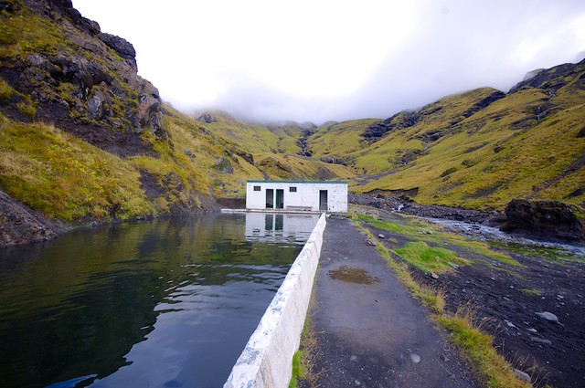
Seljavallalaug Swimming Pool
Seljavallalaug is a protected and heated 25-metre public outdoor swimming-pool in South Iceland not far off Route 1. The pool is one of the oldest swimming pools in Iceland and was built in 1923. The pool is 25 metres long and 10 metres wide and was the largest pool in Iceland until 1936. In 1990, a new pool about 2 km closer to the valley was built, but people can still go swimming in the old pool free of charge. The 2010 eruptions of Eyjafjallajökull filled Seljavallalaug with ash but it has been cleaned since.
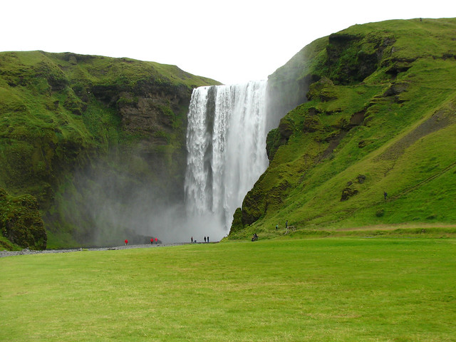
Skógafoss
Skógafoss is a waterfall situated on the Skógá River at the cliffs of the former coastline. After the coastline receded seaward the former sea cliffs remained, parallel to the coast over hundreds of kilometres, creating together with some mountains a clear border between the coastal lowlands and the highlands of Iceland. Skógafoss is one of the biggest waterfalls in the country with a width of 25 metres and a drop of 60 m. Due to the amount of spray the waterfall consistently produces, a single or double rainbow visible on sunny days. Skogar Hostel is located very close by and is a good option when looking for accommodation in the area but it is closed over the winter.
Sólheimasandur Plane Wreck
One of the more unique sites to visit in south Iceland. In 1973 this US Navy plane crash landed on the black beach at Sólheimasandur. Over the years it has deteriorated significantly and makes a great spot for some very stark photography, particularly in winter when the area around plane is covered in snow. Access to the plane is via a 4WD track. It is best to check with locals to enquire about access as there is talk of restrictions being put in place to limit the effect that tourists have on the site.
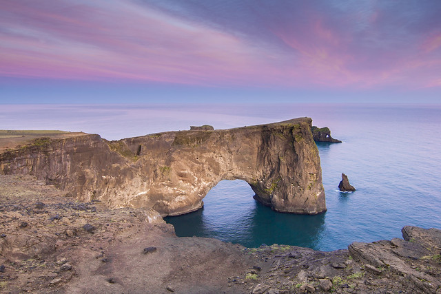
Dyrhólaey
The small peninsula, Dyrhólaey is not far from the village Vík. It was formerly an island of volcanic origin. To the north is the big glacier Mýrdalsjökull. To the east, the black lava columns of the Reynisdrangar come out of the sea, and to the west the coastline stretches out towards Selfoss. In front of the peninsula, there is a gigantic black arch of lava standing in the sea, which gave the peninsula its name. In the summertime, many puffins nest on the cliff faces of Dyrhólaey.
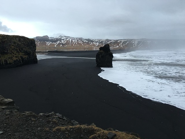
Reynisfjara
Reynisfjara is a black pebble beach and features an amazing cliff of basalt columns. Out in the sea are the basalt sea stacks Reynisdrangar. The area has a rich bird life, including puffins, fulmars and guillemots. The waves at Reynisfjara are especially strong and unpredictable. According to folklore, two trolls attempted to drag a ship to land but were turned to stone as daylight broke, turning them into the Reynisdrangar stacks, visible from the beach.
Vik
Vík is Iceland’s most southerly village and one of the most popular tourist towns in Iceland. Vík is the only seaside settlement in Iceland without a harbour. Vik is small town, but is perfectly located for an overnight stay while travelling the south coast of Iceland. Vik Hostel is the best budget accommodation and a very warm and welcoming hostel.
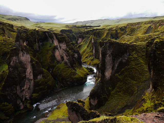
Fjaðrárgljúfur Canyon
Fjaðrárgljúfur is a magnificent and massive canyon, about 100 meters deep and two kilometres long. The canyon has narrow, sheer walls. The bedrock is mostly palagonite from the Ice Age and is thought to be about two million years old. Fjaðrá is often rather low in water and therefore hikers can safely choose to walk inside the canyon. However, wading may be necessary in spots. Deep in the canyon there are waterfalls that will eventually block the way. Most people choose to walk along a walking path up on the canyon’s edge to enjoy the view from above the canyon.
Skaftafell
Skaftafell is a great place to get up close to a glacier. The Skaftafell Visitor Centre website has all the information you need about hiking and visiting the Vatnajökull glacier. There are walking trails starting at the visitor centre that go up to the foot of the glacier. A spectacular sight. There are camp grounds located here during the summer.
Don’t miss the Svartifoss waterfall. A hiking trail to Svartifoss starts at the visitor centre and it takes about 40mins to reach the fall. The trail is very picturesque and has a couple of look out points along the way. Hundafoss is one of these stops and, whilst not quite as impressive as Svartifoss itself, is another great photo opportunity.
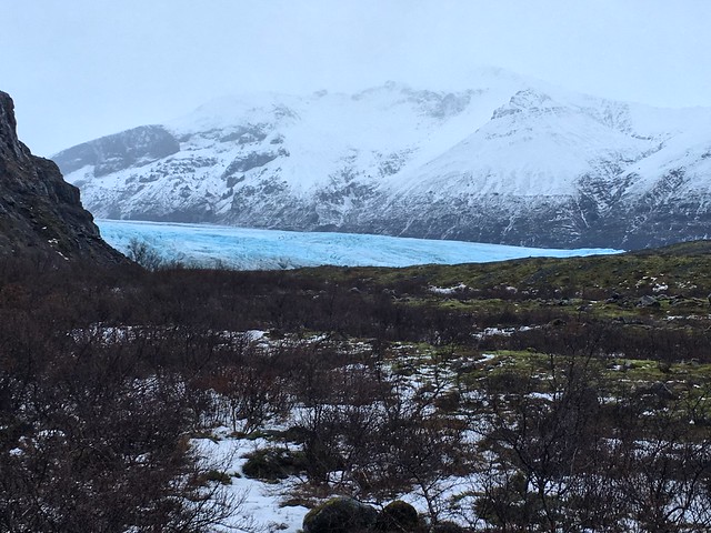
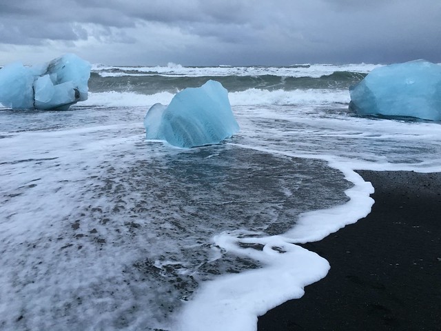
Jökulsárlón
Jökulsárlón is a large glacial lake on the edge of Vatnajökull National Park. Situated at the foot of the Breiðamerkurjökull glacier, it developed into a lake after the glacier started receding from the edge of the Atlantic Ocean. It is now 1.5 kilometres away from the ocean’s edge and covers an area of about 18 km. It recently became the deepest lake in Iceland, at over 248 metres (814 ft), as glacial retreat extended its boundaries. Many large icebergs calve off the glacier into the lagoon and eventually make their way out to sea. The icebergs then break up in the pounding waves and large junks of ice then wash up on the beaches nearby. Make sure to visit Jökulsárlón Ice Beach while you are here.
Map
Transport
There are tours available that will take you through this area of Iceland, check out extremeiceland.is for a range of options, however a much cheaper option is to rent a car and go exploring yourself. It’s possible to rent a small car for as little as 50€ per day in peak season and 30€ in winter. This will also give you greater freedom to visit all the stops in the order that suits you and at the time of day that is most convenient. The cheapest car rentals in Iceland are through sadcars.com

Leave a reply